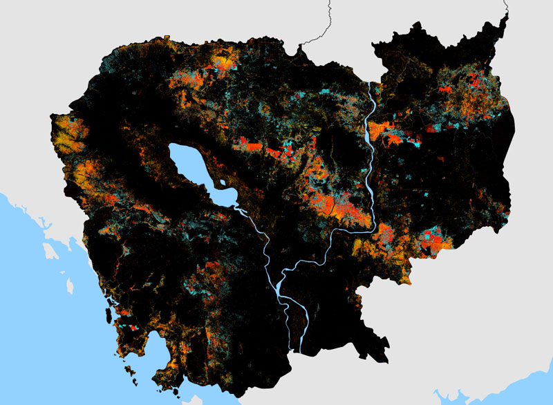
Forest loss in Cambodia between 2001 and 2014 accelerated at a faster rate than in any other country in the world, according to new global figures based on U.S. satellite data.
The annual rate at which Cambodia lost its tree cover over the past 14 years increased 14.4 percent, according to figures released this month by the Washington-based World Resources Institute (WRI) based on data compiled by the University of Maryland and Google using the satellite images.

“Cambodia is still the highest overall,” Matthew Hansen, who led the university’s research, said in an email.
Sierra Leone came in second at 12.8 percent, followed by Madagascar, Uruguay and Paraguay. Liberia, Guinea, Guinea-Bissau, Vietnam and Malaysia round out the top 10.
The Institute said the latest data identified an “alarming surge” in forest loss in four “hotspots” around the world, including the Mekong River Basin.
“With the Landsat satellite system capable of delivering global coverage every eight days, we have an unprecedented ability to monitor global forest change,” Mr. Hansen said in a statement accompanying the new data.
“The 2014 tree cover loss data, incorporating hundreds of thousands of Landsat images, confirms that deforestation is not just high in certain countries, it’s speeding up,” he said.
“The next step is to use this information to improve forest protection and more equitably balance economic development with the invaluable ecosystem services forests provide.”
Officials at the Ministry of Agriculture and its Forestry Administration could not be reached for comment.
Global Forest Watch, a WRI program, says Cambodia lost a total of 1.44 million hectares—or 14,471 square km—of forest between 2001 and 2013. That put Cambodia 23rd in the world for total forest cover lost, and ninth as a share of the forest cover the country had in 2000.
The WRI did not provide the total forest cover Cambodia lost by area in 2014. According to rights group Licadho, which analyzed the satellite data provided by the University of Maryland, Cambodia lost about 156,000 hectares of forest cover last year.
Also according to Licadho’s analysis of the data, nearly a third of the forest cover Cambodia lost last year disappeared from inside protected areas. Forty-five percent of the loss occurred inside of economic land concessions (ELCs), large tracts of land the government leases to private companies for agri-business operations, mostly rubber plantations.
The government will not release a detailed list of all active ELCs that includes the size and boundaries of each. Licadho maintains a list based on the piecemeal records the government does release and its own government sources.
Given the constraints, its figure for forest loss inside ELCs as a portion of total forest loss in 2014 —44.9 percent—is probably modest, said Mathieu Pellerin, a consultant for Licadho on land issues.
“This figure would jump at least to 50 percent if we added what is, clearly, plantations going beyond [their] boundaries, and if we would have the few remaining [ELC records] we’re missing,” he said.
Indeed, the University of Maryland’s updated map of global forest loss shows much of Cambodia’s losses continuing to take place in—and immediately around—ELCs, some of them inside the country’s protected areas. The map shows some of the most concentrated losses on and around ELCs inside the Beng Per Wildlife Sanctuary in southern Preah Vihear province and the Snoul Seima Biodiversity Conservation Area along the border of Kratie and Mondolkiri provinces.
The government claims that it leases out ELCs only over degraded forests already stripped of their public value by settlers, poachers and illegal loggers. But none of the country’s protected areas have the legally mandated zoning maps that are supposed to show where the degraded areas are, and few ELCs were preceded by the environmental impact assessments also required by law.
Recent satellite data gathered by NASA measuring carbon emissions from forest fires show that the ELCs actually overlap with some of the least degraded forests in Cambodia.
In July, U.S.-based environmental rights group Forest Trends said it looked at NASA’s forest fire data for Cambodia’s 2012-2013 dry season. It said emissions from evergreen forests being cut down inside ELCs were 10 times higher than emissions from outside of concessions, “confirming that corporations are targeting the oldest and most valuable forests, many of them on national forest lands, for logging.”
Local rights groups—including Licadho—have long accused the government of granting many of the ELCs as a way around an official ban on logging concessions. Under mounting pressure at home and from abroad, the government put a freeze on granting new ELCs in mid-2012, though about 30 were approved in the months that followed.
Despite Cambodia’s place atop the list of countries that saw the fastest increases in forest loss over the past 14 years, Cambodia’s year-on-year tree cover loss actually fell in 2014. Licadho’s Mr. Pellerin said the 2012 freeze on new ELCs may finally have started to pay off, but added that it was too soon to say whether the country had turned a corner.
“The moratorium on new ELCs would start in 2014 to have a tangible impact, whereas [in] previous years, fresh ELCs granted soon before the moratorium or after were still clearing,” he said.
According to the WRI, the world lost more than 18 million hectares of tree cover in 2014, an area twice the size of Portugal.